Robotic navigation technology explores the deep sea
18. Mai 2021Robotic navigation technology explores the deep sea
New York,5/18/2021
On May 14, the National Oceanic and Atmospheric Administration (NOAA) ship Okeanos Explorer will set sail from Port Canaveral, Florida, on a two-week expedition led by NOAA Ocean Exploration to demonstrate autonomous underwater vehicle technology. Named Orpheus, this new class of underwater robot will showcase a system that helps it find its way and identify scientifically interesting features on the seafloor.
Terrain-based navigation helped NASA’s Mars 2020 Perseverance rover make its precision landing on the Red Planet on Feb. 18. The system allowed the descending robot to visually map the Martian landscape, identify hazards and then choose a safe place to land without human assistance. Similarly, the agency’s Ingenuity Mars Helicopter uses a visual navigation system to track surface features on the ground during flight to estimate its movements over the Martian surface.
The version of visual navigation developed higher by engineers at NASA’s Jet Propulsion Laboratory in Southern California, which has already been used on Mars, is now being tested a little closer to home: off the U.S. East Coast in the Atlantic Ocean.
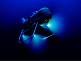
Navigating the dark and often murky waters near the ocean floor would normally require large, powerful tracking devices such as sonar. Using a low-power system of cameras and lights, along with advanced software, Orpheus is an order of magnitude lighter than most deep-sea submersibles. Smaller than a quad and weighing about 250 kilograms, Orpheus is designed to be maneuverable, easy to operate and rugged while exploring depths unreachable by most vehicles.
Developed by Woods Hole Oceanographic Institution (WHOI) in collaboration with JPL, Orpheus can operate untethered almost anywhere in the ocean, including the most extreme depths. Ultimately, the project team hopes that a swarm of these underwater robots will work together as a team to create 3D maps of the vast regions of unexplored seafloor in the Hadal Zone – regions deeper than 6,000 meters. But before the robot can explore these depths, it must first be put through its paces in shallower waters.
„This tech demo will be used to collect data to demonstrate the viability of terrain-based navigation in the ocean, while also showing how multiple robots can work together in extreme environments,“ said Russell Smith, robotics mechanical engineer at JPL. „These tests put us on the right track to launch future dives into the Hadal Zone and intelligently detect exciting regions of high biological activity.“
Orpheus‘ version of visual-assisted navigation is called visual inertial odometry, or xVIO, and works by using a system of advanced cameras and pattern recognition software along with instruments that can precisely measure its orientation and motion. As Orpheus drives across the seafloor, xVIO identifies features – such as rocks, shells and coral – beneath the vehicle. Like memorizing landmarks while driving a car, xVIO creates 3D maps that use these features as waypoints to navigate. But this system is more than just a means to prevent the diving robot from getting lost.
The high-resolution maps that xVIO creates are stored in memory so that when Orpheus returns to the area, it recognizes the unique distribution of features and uses them as a starting point for further exploration. And when collaborating with fellow robots, the maps can be shared, cross-referenced and evolved to quickly identify areas of scientific interest.
„In the future, some of the most extreme ocean environments will be within our reach. From deep ocean trenches to hydrothermal vents, there are many new targets we will explore,“ says Andy Klesh, a systems engineer, also at JPL. „By staying small, we’ve created a new, simplified tool for ocean explorers – one that will directly benefit NASA as an analog system for autonomous space exploration.“
But Klesh pointed to another benefit of collaboration between NASA and organizations such as WHOI and NOAA, with their extensive oceanographic expertise: The technologies being developed to explore Earth’s oceans with smart, small, and robust autonomous underwater vehicles could ultimately be used to explore oceans on other worlds.
Earth analogs are often used as ecological proxies for other places in the solar system. For example, Jupiter’s moon Europa has a subsurface ocean where conditions could be favorable for life.
„At hadal depths on Earth, the pressure is about the same as Europa’s subsurface ocean, which is thought to be about 80 kilometers deep,“ says Tim Shank, the biologist who leads WHOI’s Hadal Exploration (HADEX) program. „The idea that this expedition could be the springboard to new discoveries about our own planet, including answering the most fundamental question, is profound: Is there life only on Earth, or are there other places beyond this pale blue dot where life could have originated? But before we can explore Europa or any other ocean world, we must first better understand our own home.